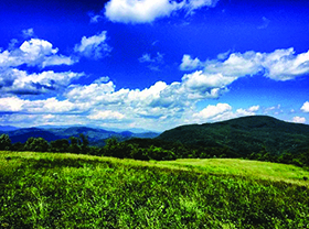


The Trombatore Trail climbs and descends over 2.4 miles along the Eastern Continental Divide, through the Upper Brush Creek Watershed. The trail terminates
in and expansive meadowed summit known as Blue Ridge Pastures. Plans are under way for this trail to eventually connect with the three others in the
vicinity (Bearwallow, Little Wildcat Rock, and Florence Nature Preserve) to form a lengthy network of hiking routes in the Upper Hickory Nut Gorge.
For many more details about the trail and the future trail network plans see Conserving Carolina’s trail page below:
https://conservingcarolina.org/trombatore-trail/
The trail is part of the newly designated Hickory Nut Gorge State Trail System. That system is envisioned to be more than 100 miles of trails throughout
Hickory Nut Gorge. To read more about the plans and see a map of the current and proposed trails see the link below:
https://conservingcarolina.org/hickory-nut-gorge-trail/
WHERE: Hendersonville, NC
DIRECTIONS: Trailhead is at Bearwallow Gap, located at the crest of Bearwallow Mountain Road where the pavement turns to gravel. Once at the trailhead, park on the shoulder of the road making sure not to block the gate or the road. Space is available for only a few cars at this trailhead.
Weather can change quickly in the mountains. Always tuck rain gear into your backpack and bring along layers of clothes.