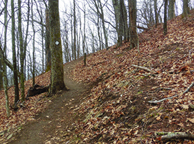


Straddling the Eastern Continental Divide, the mountain has been a popular destination for local hikers who knew about it for years. Now, thanks to a conservation
easement on the land and a beautiful new trail leading to the top, it’s been officially opened to the public for hiking. Right now, there is one excellent
trail at Bearwallow Mountain (called the Bearwallow Mountain Trail), and by combining it with the gravel road which was traditionally used as the route
to the top, you can make a great loop hike. The trail is beautifully constructed with some nice rock work, as it switches back and forth across the
western ridge leading up to the summit.
At the top, you may encounter the local bovine population as they graze on the meadow grass. This trail also shares a trailhead with the Trombatore Trail,
which starts on the opposite side of the road.
NEW: The Bearwallow Mountain Trail now connects to the Wildcat Rock Trail! At the top of Bearwallow Mountain, look for the signs that connect you to the Wildcat Rock Trail which leads to Little Bearwallow Mountain and Little Bearwallow Falls.
For more details about the trail, the mountain and future plans in the see Conserving Carolina’s link below.
https://conservingcarolina.org/bearwallow-mountain/
The trail is part of the newly designated Hickory Nut Gorge State Trail System. That system is envisioned to be more than 100 miles of trails throughout
Hickory Nut Gorge. To read more about the plans and see a map of the current and proposed trails see the link below:
https://conservingcarolina.org/hickory-nut-gorge-trail/
WHERE: Gerton, NC
DIRECTIONS: The trail is located near the Gerton community in northeastern Henderson County. The trailhead is on Bearwallow Mountain Road. From Lake Lure/ChimneyRock, take US 64/74-A towards Bat Cave. At the 64 and 74-A split, continue straight on 74-A. Drive for 5 miles and turn left on Bearwallow Mountain Road. Drive two miles up a narrow gravel road to the trailhead. There is very limited parking at the trailhead.
Hopefully you won’t ever need to use it, but what happens if the batteries in your GPS are dead?