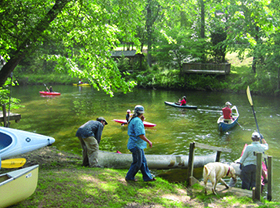


Beautiful trip with little noticeable development and largely tree lined banks. No navigation trouble spots though there are usually a large number of downed trees to maneuver around.
Trip time is 4 hours at normal water levels.
WHERE:
DIRECTIONS:
Put-In: No official or public take-out here, though the property owners there are OK with limited paddler use on the left bank before the bridge. Please park only near bridge on Thompson Lake Road. Do not park in field farther down Thompson Lake Rd. The informal access is directly under the bridge.
Take-Out: Rutherford County's first official public access! Gravel parking, concrete steps to the river with rails to ride boat down and an articulating dock. Very nice! Managed by NC Wildlife Resources.
Keep your maps in a plastic bag to protect them from the rain and know how to use them. GPS units are great, but they are not substitutes for knowing how to use a map and compass.